BIOL 4120

Principles of Ecology

Phil Ganter

320 Harned Hall

963-5782

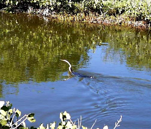
An Anhinga (Snakebird) swims up a Florida mangrove creek

Lecture 21 Aquatic Ecosystems

Email me

Back to:

Overview - Link to Course Objectives

Excellent maps of the distribution of most of the ecosystems discussed below are quickly available on the web (click here, for freshwater ecosystems and here for marine ecosystems), provided by the National Geographic Society.  You first go to a map, which you can zoom up or down.  To see pictures and get more information, click on the region of interest on the map (usually in light blue) and a new page will come up.

Freshwater (Lentic) Ecosystems (24.1, 24.2, 24.3, 24.4)

Fun water facts

  • Water is densest at 4° C
  • Cold water holds more O2 than warm water

Lentic habitats are wetland, lake and pond communities

  • Ponds have plant and algal growth on bottom (light reaches bottom) and no vertical zonation, whereas lakes have water deep and/or dark enough so that the bottom has no photosynthesis occurring and have vertical stratification
  • Lakes and ponds are, in general, temporary features of the landscape
    • they fill in over time as Sediments (both mineral and organic) fall to the bottom, where low oxygen and temperature conditions slow decomposition
  • Lake Basins - form from:
    • damming streams or rivers (human-built and natural dams) - beavers, debris, and rock/mud slides all can dam a waterway
    • action of glaciers that scrape out depressions, the terminal moraine (ridge of loose rock pushed up at the end of a Glacier [slow-moving river of ice pushed forward by buildup of new ice behind the leading edge]
    • Rift Lakes form where the continental rock lies over the spreading edge of two Tectonic Plates that are moving apart.  Rift lakes are very deep and grow as the plates continue to move apart instead of shrink as the fill in
  • Aquatic organisms that live off of the bottom in the water column (in fresh or marine ecosystems) can be:
      • Click the links to see images of the organisms -
    • Plankton - usually small organisms that drift freely in the water or, if they can swim, swim distances that are small in comparison to the distances through which they drift
  • Lakes can be divided into zones using more than one scheme.
    • Thermal Lake stratification - a brief review (from lecture on aquatic environments)
      • Epilimnion - wind-mixed upper layer of lake
      • Thermocline - region of steep change in temperature which separates upper and lower waters
      • Halocline - region of steep change in salinity which separates upper and lower waters in salty lakes
      • Hypolimnion - lower, colder water (4° C), does not mix with upper layer
    • Overturn is when upper layer is cooled to temperature of lower layer and wind can mix upper and lower layers
    • Photosynthetic Zonation - this zonation is both vertical (Photic-Profundal-Benthic) and horizontal (Littoral - Limnetic)
      • Photic zone is where there is enough light enough to support photosynthetic organisms
        • the Compensation Depth is the depth at which photosynthesis just balances respiration and separates the productive upper waters (above the CD) from the lower regions where respiration demands are larger than photosynthetic productivity
          • Light penetration depends on absorption (by water, dissolved materials, or suspended particles like silt or algae) and scattering (which sends some light back toward the surface)  Water, dissolved materials, and suspended particles all scatter light
          • Water absorbs light but not until bright sunlight penetrates to hundreds of meters (200 m is about as deep as the CD ever gets
          • Light is absorbed as a function of wavelength (shorter wavelengths penetrate deeper) so that algae that photosynthesize in deeper waters are usually red (the reflect but do not absorb red light - the wavelengths that are not usually available at the depth where they live)
        • The depth of the photic zone often depends on lake productivity (more algae in the water means that light penetrates less deeply into the water)
      • Profundal Zone - where no photosynthesis takes place and where all food is imported from above the CD
        • often becomes anoxic due to lack of mixing and oxygen demand from decomposition
      • Benthic zone (Benthos) is the bottom of the lake
        • Where dead organisms and inorganic debris accumulate and where most decomposition occurs
        • This is the region where oxygen consumption if often greatest and is also the part of the lake farthest from the point of entry of oxygen into the lake (the surface), which means that the benthos is the first place to become Anoxic.
      • Littoral zone is the edge of the lake where light hits the bottom and there are often rooted, aquatic plants growing
      • Limnetic zone is the euphotic zone in open water, where there is a profundal zone under the limnetic zone
        • unicellular algae are primary producers in this zone
        • Oligotrophic lakes are clear, low-productivity lakes
        • Eutrophic lakes are turbid, high-productivity lakes
        • Dystrophic lakes have brown-stained water (sometimes called cedar water) from the incomplete decomposition of organic material
          • the organic material may be from autochthonous littoral productivity or from adjacent wetlands

Freshwater Wetland Ecosystems (25.6, 25.7, 25.8)

  • Important - 6% of terrestrial habitat - but tend to be local and small (see last part of this section  for some exceptions)
    • range from constantly flooded land to soils that are only episodically saturated with water
  • water saturation leads to anoxic conditions that are tolerable for plants adapted to flooded soils - Hydrophytes
    • Obligate Hydrophytes are found only on flooded soils (this group also includes plants adapted to the littoral areas of ponds and lakes)
    • Facultative Hydrophytes are capable of living on soils never flooded but prefer flooded soils
  • wetlands develop in three topographic situations
    • shallow basins - small basins in uplands from which there is no drainage so precipitation gathers there or depressions that were once lakes and ponds but accumulated organic and mineral sediments have filled them in.
      • Water flow is vertical and downwards as precipitation flows into the system (from surrounding areas)
    • shallow river banks - low areas adjacent to rivers that with soils saturated because the water table is near the surface - often flooded when the river level rises
      • water flow is unidirectional and horizontal in the direction of river flow
    • lake fringes - edges of lakes with soils saturated by the high water table
      • bidirectional horizontal water flow as lake levels change moves nutrients and sediments into and out of the wetland
  • Wetland Structure
    • defined by the Hydrology that created the wetland
      • Water source, flow and chemistry
      • Hydroperiod - the frequency, seasonality, duration, and depth of flooding
    • the primary productivity of wetlands depends on the source of water
      • groundwater and rivers bring lots of nutrients and result in productive wetlands
      • precipitation brings in less nutrients and results in lower productivity

Types of wetlands

  • Marsh - wetlands with emergent herbaceous (non-woody, like the grasses in a salt marsh) vegetation
  • Swamp - wetlands with emergent woody vegetation (trees, usually)
  • Riparian Woodlands (Bottomlands, Bosque) - wetland woods along rivers, may be seasonally
  • Peatland (Mire) - wetlands with an accumulation of undecomposed plant material (Peat)
    • Bog - mires with precipitation as the primary input of water, unproductive as there is no source of nutrients other than rainwater and acidic because the anoxic decomposition produces lots of organic acids
      • one plant that will grow under these circumstances is the moss Sphagnum, which dominates bogs
      • Blanket Mire or Raised Bog (Moor) - upland mire where a layer of compressed peat forms an impermeable barrier that retains the water in the mire above the water table
          • The area of saturated soil above the impermeable peat barrier is called a Perched Water Table (like a bird perching on a limb)
    • Fen - mires with a source of groundwater as their primary input of water, more productive than bogs because of the nutrient input by the groundwater flow
      • fens and fen peat are dominated by sedges (members of the angiosperm family Cyperaceae that includes two plants you might recognize - water chestnuts and the papyrus sedge that the ancient Egyptians used for paper making)
    • Quaking Bog - when a lake is overgrown by Sphagnum, the overgrowth can form a layer so thick that you can walk on it, although it will "quake" when you do so
  • Flooded Grasslands (and Flooded Savannas) regions that are regularly flooded, usually seasonally but some, like the Sudd and the Everglades, are flooded all year
    • these are productive ecosystems of moderate diversity and endemism
    • these are threatened systems as humans tend to drain them for conversion to agricultural land or to take the abundant water for human use
    • examples are the Everglades [image] in Florida, the Sudd [image] in southern Sudan (also areas of the Sahel around Lake Chad and along the Niger River) and Zambezian flooded savannas of the Okavango River system [image] in Africa, the Rann of Kutch [image] in India and Pakistan, and the Pantanal [image] in South America
      • the Pantanal, located where Bolivia, Paraguay, and Brazil come together, "supports over 260 species of fish, 700 birds, 90 mammals, 160 reptiles, 45 amphibians, 1,000 butterflies, and 1,600 species of plants." (World Wildlife Fund)
      • the Everglades are
        • a river only a foot deep in most places that flows over a flat plain of limestone (fossil coral reef)
        • "11,000 species of [angiosperms], 25 varieties of orchids, 300 bird species, and 150 fish species" (World Wildlife Fund)

Lotic Ecosystems are running water - stream and river - communities (24.5, 24.6, 24.7)

No clear distinction between stream and river except size and no clear point at which streams become rivers

Watershed - a geographical region that is drained by a single stream or river, including all of the Tributaries (streams or rivers that are upstream and flow into a stream or river - sometime called Headwaters) of that stream or river

  • Each tiny stream has a watershed that is part of the larger watershed of the stream or river into which the tiny stream flows
  • The watershed of the small stream that flows past the western entrance to TSU consists of the adjacent hills (along 36th Ave) with runoff that drains into the stream
  • The stream flows directly into the Cumberland River, which has a watershed that includes all of upper Middle Tennessee, parts of southern Kentucky, and parts of upper East Tennessee
  • The Cumberland flows into the Ohio River, which has a watershed that drains western Pennsylvania, southeastern Illinois, most of Ohio, Indiana, and Kentucky as well as upper Middle and East Tennessee
  • The Ohio flows into the Mississippi River, which has watershed that drains 41% of the surface of the US between the Appalachian and Rocky Mountains

Stream Order - since streams flow into other streams, stream order is a classification scheme for streams and rivers based on how a stream forms:

  • First Order streams - a stream with no tributaries - it may begin as a spring or a wetland
  • Second Order streams - begin as the confluence of two first-order streams
  • Third Order streams - begin as the confluence of two second order streams, etc.
  • What happens if a second order stream and a third order stream come together?
    • The new stream is still third order.  Order goes up only when two streams of the same order come together.  A drainage ditch flowing into the Mississippi would not alter the order of the Mississippi

Lotic ecosystems are affected by the rate of water flow, which depends on the slope (steepness)of the stream and the volume of water flowing

  • Flow rate will determine if the stream or river scours the bottom of the stream or leaves sediments
  • Many animals are adapted to streams with particular flow rates and will not live in faster or slower water
  • Streams often are structured into two flow regimes [image, image]
    • Riffle - where the stream flows faster, is shallower, and the bottom is often scoured of debris
    • Pool - deeper areas where water accumulates and flow rate  decreases so that debris are deposited
  • Streams with riffles and pools have them alternatively (since there are only two types, this order is a logical n

Energetic inputs into streams

  • Autochthonous Production in Lotic systems - this is carbon fixed by photosynthesis in the stream or river and is accomplished by:
    • Attached Phytoplankton (single-celled algae, also called Periphyton) on the stream bottom,
    • Plants (along banks),
    • floating Plankton in large, slower-moving rivers
  • Allochthonous Production  - much organic material comes into running water from:
    • adjacent land in the from of leaf and other plant litter blown into the stream or carried there by runoff of precipitation
    • lake outflow brings organic material produced in the lake

Feeding adaptations in lotic systems

Many invertebrates are both primary consumers (mostly of Periphyton) and decomposers (of the allochthonous plant litter)

  • Grazers - consume periphyton by scraping surfaces
  • Shredders - graze on dead materials by chewing CPOM (Coarse Particulate Organic Material - mostly leaves) into smaller bits and digesting what they can as the material passes through their guts
    • most of the high-quality food for shredders are the bacterial and fungi that are decomposing the CPOM
    • the use of the odd term CPOM is due to the fact that when working in streams, it is often impossible to tell the source of debris and so some kind of over-all term was needed (whether one might think "coarse particulate organic material" is a bit pompous is a value judgment that does not reflect on the need for a term)
  • Filter Feeders - these are organisms that use either hairs (called setae) on their own bodies or nets (usually of silk - these are insects and many orders of insect can spin silk) to filter particles from the water
    • filter feeders eat FPOM (Fine Particulate Organic Matter) which is a mix of debris, bacteria, and plankton
  • FPOM is smaller than CPOM and will remain suspended in the water column at lower rates of  flow than CPOM
  • Gathering Collectors - insect larvae that can pick up CPOM from the sediment at the stream bottom
  • Gougers - insect larvae that can burrow into larger, woody debris for their food

Stream Drift

  • Debris and the organisms that feed on them are carried downstream by the constant flow of water
  • Adult insects are responsible for moving upstream by flying there

Freshwater-Marine Interface - Estuaries and Barrier Islands (24.8)

  • Estuaries are where fresh and salt water mix, stressful for organisms
  • Mudflats and marshes common
  • High primary productivity but low species diversity
  • animals must deal with
    • maintaining their position in the marsh as tides and river flow mean that the water is constantly moving but not always in the same direction
    • adjusting to varying levels of salinity as the estuary has
      • a gradient of salinity from freshwater in the river above the region affected by tides to ocean salinity near the mouth of the estuary
      • the gradient can move with the tides and the season
        • varying inputs of fresh water as river flow varies with the amount of precipitation in its watershed
        • twice (in some places once) daily tidal cycles which bring ocean water into the estuary
  • Barrier Islands form where sand is carried toward shore by waves until it piles into low islands of sand just off of the coast
    • The East Coast of the US is a system of barrier islands that begin in Mexico (Padre Island is the first island in Texas), line the Gulf coast, wrap around Florida, and run up the eastern Coast until Long Island, New York, where the system ends
    • the islands have a lens of fresh water (from precipitation - normally the only source of fresh water on these islands) in the sand above sand soaked by salt water
      • this fresh water means that the islands are often forested
      • usually low forests but there is an exception - Fraser Island, Australia, the largest barrier island where the sand is piled over 700 feet above sea level and there is sufficient rain to support a temperate "Littoral" rain forest and the trees can reach heights of over 150 feet (over 200 feet prior to logging)
        • once again, rainforests can develop on top of very low-nutrient soils (the sandy soils of barrier islands are, in general, nutrient poor)
  • north of Long Island, the coast is mostly rocky, not sandy, and the offshore islands are also rocky, not sandy
  • Lagoons - the waters between the coast and the back side of the barrier islands
    • salinity varies greatly, depending on the input of fresh water from estuaries and in the rate of evaporation, which can increase salinity above that of the adjacent ocean
    • often surrounded by productive salt marsh systems (see below)

Marine Communities

Ocean Zonation (24.9, 24.10, 24.11)

  • Intertidal zone (25.1, 25.2, 25.3, 25.4, 25.5)
    • Littoral Zone - the area between high and low tide marks
    • Supralittoral Zone - the "spray zone" above the littoral zone - the transition from terrestrial to marine habitats
    • Air to water oscillation tends to stress organisms
    • intertidal organisms are exposed to both land and marine predators and herbivores
    • there are four general types of intertidal habitats
      • Rocky Intertidal - organism persist by attaching to rocks but must be able to survive periods of exposure to air
        • sessile community is organized into linear zones parallel to the shoreline
          • lower littoral - oysters, mussels, macroalgae and microalgae
          • middle littoral - mussels, limpets, chitons
          • upper littoral - acorn barnacles
        • the zonation is the result of several processes - competition for space, predation, and tolerance of the physical stresses (exposure to air, wave action)
        • waves are a stress but also the source of constant input of nutrients for algae and food for the animals that live on the rocks
      • Sandy Beaches and Mudflats -
        • Sandy Beaches - harsh environment where waves deposit and move sand
          • flora and fauna limited to a small number of species that can tolerate the constant battering
        • Mudflats - less wave action and gradual beach slope deposits fine particles that result in mudflats
        • Fauna divided into
          • Epifauna - animals that live on the surface of the mudflats (few epifaunal organisms on sandy beaches) - snails and crabs
            • on sandy beaches, most epifauna is supralittoral
          • Infauna - animals that live below the surface
            • Macroinfauna - burrowing clams, crustaceans, echinoderms (sand dollars and heart urchins) and many polychaete annelids, many of which construct permanent burrows
            • Meiofauna - small animals from several phyla that have adapted to living between the sand grains and mud particles
        • Productivity
          • waves deposit lots of organic material and bring planktonic food so there is a large decomposer community and filter feeders that remove plankton
            • wave action usually does not disturb mudflat sediment, so oxygen must diffuse into the soils and, because there is so much organic matter deposited, there is insufficient oxygen to decompose it and the soils of mudflats are anoxic
          • microalage live between the sand grains and form a productive layer in sandy beaches but below the surface where they are not disturbed by normal wave activity, there is more moisture than on the surface and it's cooler, and enough light for photosynthesis
      • Salt Marshes - low energy areas are not always mudflats but, in temperate regions, are often dominated by a type of grass called cordgrass in the genus Spartina
        • high productivity areas because of the input of nutrients with each tide
          • much of the productivity is available to the predators (fish and crabs or birds and mammals) that come and go with the tides
          • salt marsh productivity supports coastal fisheries
        • drainage of the tides from the marshes causes the formation of Tidal Creeks that erode to depths below the low tide level and, so, are filled with water even at low tide
        • Spartina (cordgrass) is tolerant of high salt levels, daily inundation, water-logged soils (there are hollow air-filled tubes in the stems and roots that allow gas exchange)
          • Spartina patens - found in high marsh, short plants, tolerate the higher salinity and decreased nutrient input found in the high marsh (height refers to height above low tide level)
          • Spartina alterniflora - found in low marsh, where the more favorable conditions allow greater productivity
      • Mangrove Forests (Mangals) - found on tropical, low energy (sheltered, waveless) coasts
        • mangroves have spreading roots, often with Prop Roots to help stabilize the plant or Pneumatophores (hollow root extensions) that reach above high tide level to allow for gas exchange with the atmosphere
        • tangles of prop roots offers a complex environment with many species, many of which attach to the roots (clams, oysters, and mussels, barnacles)
        • constant water motion provides constant input of nutrients and mangrove forests are very productive
  • Pelagic Zone - the waters of the ocean
    • Neritic Zone - shallow ocean over the Continental Shelf
      • Continental shelf is the edge of the rock formations that make the continents - lighter rock that "floats" on the more dense rock of the ocean floor
    • Oceanic Zone - deep, open ocean,
        • "Blue water areas" low productivity; green ocean is high productivity
        • High productivity oceanic areas caused by upwelling of deeper, nutrient-rich water
      • Photic Zone = Epipelagic Zone - water above the compensation depth, usually not deeper than 200 m
      • Mesopelagic Zone - to 1000 m deep - little light and little seasonal variation
      • Bathypelagic Zone - to 4000 m - no light and very high pressures
      • Abyssopelagic Zone - from 4000 m to bottom, unless the bottom is in a Deep Sea Trench
        • trenches are formed by the edge of a Tectonic Plate being pushed under another plate
      • Hadalpelagic Zone - can reach 7000 m in trenches
  • Benthic Zone - the bottom of the ocean
    • ocean averages almost 4 km deep (closer to 5 km if the neritic zones are not included in the calculation), so the benthos is:
      • uniformly cold (4°C water is densest and sinks to the bottom)
      • under tremendous pressure (~1 atmosphere for every 10 m of depth, so 4 km deep means about 390 atm, or over 5,700 pounds per square inch) from the weight of the water above
    • benthos is often covered with a layer of Red Clay or the remains (shells) of plankton as a thick layer of mud called Ooze
      • oozes are named for the type of plankton that dominates in the water column above them
        • Globigerina ooze - covers more of the ocean bottom than any other seafloor type - Globigerina is a Foraminiferan (a protist with a calcareous shell)
        • colder waters have mostly oozes made of silica shells (Radiolaria or Diatoms)
    • Volcanic vents
      • For a brief discussion of Plate Tectonics go to Seafriends
      • Sea floor spreading causes volcanism
        • as hot mantle material comes to the surface it cools and forms the Midocean Ridges
      • where the ridges or other volcanic activity on the sea floor is, vents can form
      • vents are home to one of the most unusual ecosystems on Earth, only discovered in 1977
        • Bacteria are the primary producers and many species unique to the vent system have evolved to take advantage of this productivity (see discussion of benthic productivity below)
  • Oceanic Productivity (24.14, 24.13)
    • Pelagic Photic Zone productivity
      • Thermoclines form in oceans just like lakes and have the same effect on productivity
        • thermoclines divide the water column and prevent mixing of the lower and top layer
          • deeper water is the source of inorganic nutrients needed for primary production, as in lakes, and the thermocline can limit productivity by preventing mixing
        • two events promote mixing:
          • seasonal breakdown of the thermocline (as in lakes) that allows mixing by winds
          • Upwelling - where winds blow surface water away from continents or where surface currents diverge (along the equator), the only source of water to replace that water is the deeper water, which "upwells" and brings nutrients to the surface (i. e., the Photic Zone) so upwelling areas are among the most productive ocean waters
      • Tropical open ocean waters have a permanent thermocline and productivity is low (those clear, tropical seas)
        • nutrients are recycled within the photic zone and the rate of recycling sets the rate of primary production
    • Neritic Photic Zone productivity
      • the continents provide nutrients through
        • water runoff and river flow
        • dust blow
      • nutrient level and, therefore productivity, is higher in neritic than pelagic photic zones (except in areas of upwelling)
    • Coral Reefs (24.12) - diverse communities of algae, invertebrates, and fish that occur in tropical and sub-tropical waters as:
      • long Barrier Reefs that form offshore along continents
      • small Patch Reefs that form in shallow coastal water
      • Fringing Reefs that project from the rocky shores along continents and around sea mounts that rise above sea level or get very close
      • as Coral Atolls, where the reef surrounds a lagoon left behind as the original volcanic island rock erodes away
      • formed by deposition of Calcium Carbonate by various animals, primarily Hard Corals (Cnidaria: Anthozoa)
        • coralline algae, mollusks, some sponges and some polychaetes also contribute
      • Hard Corals are a mutualists with single-celled algae (See Lecture 15 for a description) and so they need light
        • Coral reef are found in clear, warm (but not too warm) waters
        • Clear waters are unproductive (if they were, they would not be clear)
        • the waters are nutrient-poor
      • Coral reefs are very productive (comparable to rain forests) even though the water is nutrient poor because they are Nutrient Traps
        • as water flows over the reef, organisms draw the nutrients from it, and the depleted water is constantly replaced by the constant water flow
        • plankton in the water near a reef are moving with the water and only get nutrients that diffuse into their neighborhood - a very slow process
    • Benthic Productivity
      • Benthic zone receives most of it energy input as a "rain" of dead plant and animal material from the waters above it
        • Where humans have greatly increased this input (by dumping garbage and sewage or polluted river flow), the oxygen consumption increases to a level which depletes the bottom waters of oxygen
        • This anoxic zone (referred to as a "Dead Zone" in political debate) may be seasonal but has an important impact on the benthic community and the fish and shellfish that feed on it
      • Autotrophic production in the benthos is limited to Chemoautotrophy, mostly where vents are produced by tectonic activity
        • As material from the Earth's mantle moves up to the surface of the seafloor, it bring reduced, soluble compounds with it
        • Vents are cracks where water is able to seep into this newly exposed rock and dissolve these reduced compounds
          • The mantle rock is still hot and it heats the water, which forces the water out of the cracks as jet-sprays of superheated water, rich in reduced compounds
            • the precipitates may be deposited around the exit cracks,forming Chimneys (some dozens of meters high)
          • the water can be up to four hundred degrees (celsius) but unable to turn to steam due to the great pressure found at the ocean bottom
          • as the water cools through contact with the 4°C ocean water, the mineral precipitate as fine particles and the vent looks like smoke rising from a hot fire
              • hot vents, with lots of iron sulfides, are Black Smokers (see one here)
              • cooler vents, with compounds of barium, calcium and silicon, are White Smokers
        • Chemosynthetic Bacteria metabolize the reduced compounds (H2S is the most important compound) and are the Primary Producers in the Vent Ecosystems
          • Productivity is high, comparable to forest productivity

Terms

Lentic Ecosystem, Sediment, Lake Basin, Plankton, Phytoplankton, Zooplankton, Nekton, Photosynthetic Zonation, Photic zone, Compensation Depth, Profundal Zone, Benthic zone, Benthos, Anoxic, Littoral zone, Limnetic zone, Oligotrophic lake, Eutrophic lake, Dystrophic lake, Hydrophyte, Obligate Hydrophyte, Facultative Hydrophyte, Hydrology, Hydroperiod, Marsh, Swamp, Riparian Woodlands, Bottomlands, Bosque, Peatland, Mire, Bog, Sphagnum, Blanket Mire, Raised Bog, Moor, Fen, Quaking Bog, Flooded Grasslands, Flooded Savanna, Lotic Ecosystem, Watershed, Tributary, Headwater, Order, First Order, Second Order, Third Order, Riffle, Pool, Autochthonous Production, Periphyton, Allochthonous Production, Grazer, Shredder, CPOM (Coarse Particulate Organic Material), Filter Feeders, FPOM (Fine Particulate Organic Matter), Gathering Collector, Gouger, Stream Drift, Estuary, Barrier Island, Lagoon, Intertidal zone, Littoral Zone, Supralittoral Zone, Rocky Intertidal, Sandy Beaches, Mudflat, Epifauna, Infauna, Macroinfauna, Meiofauna, Salt Marsh, Tidal Creek, Spartina patens, Spartina alterniflora, Mangrove Forests, Mangals, Pelagic Zone, Neritic Zone, Continental shelf, Oceanic Zone, Photic Zone, Mesopelagic Zone, Bathypelagic Zone, Abyssopelagic Zone, Deep Sea Trench, Hadalpelagic Zone, Benthic Zone, Red Clay, Ooze , Globigerina ooze, Upwelling, Barrier Reef, Patch Reef, Fringing Reef, Coral Atoll, Vent, Chimney, Black Smoker, White Smoker

Last updated April 15, 2007