|
BIOL 4140
Contemporary Problems
in Environmental Science
Phil Ganter
302 Harned Hall
963-5782 |
|
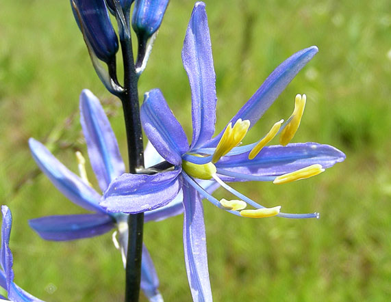
Camassia quamash,
Quamash
or Camas, are related to asparagus and have edible bulbs |
Biodiversity
Chapter 3
Email
me
Unit
Organization:
Reading:
Textbook: Chapter 4
Ancillary Reading:
Single Origin for Life
Origin
of life can be seen as a multistep accumulation of chemical complexity
have
to explain how self-replication, control of metabolism, and information
storage arose from chemical interactions under the conditions prevailing
over 3 billion years ago
Evidence for a Single Origin
Looking
for common features of all living things that are common to all due to history,
not function
- Universal
genetic code
- Use
of L-amino acids
- Ribosomal
RNA sequence
- Conserved
amino acid sequence for non-functional portions of some proteins
- Conserved
codon usage for redundant codons
- Use
of ATP for vast majority of metabolic reactions
Brief History of Life
Major Features
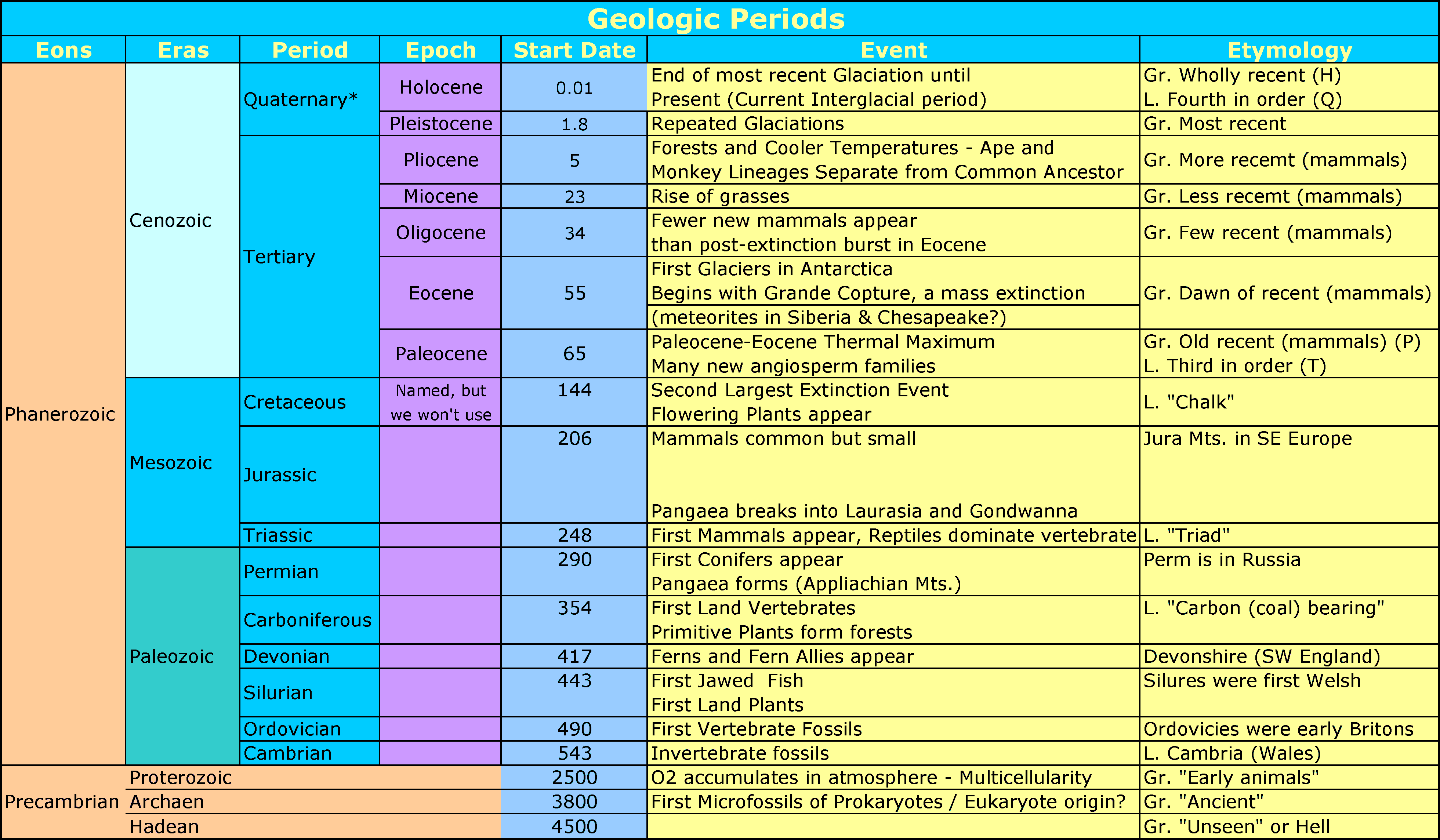
- 4.5
bya - Origin of Earth
- 3.8
bya - Origin of life
- 2.8
bya - O2 appears
in the atmosphere
- 2.1
bya - Eukaryotes appear
- The
time since the origin of the Earth has been divided into four
"eons"
- The
first eon covers up until life appears
- The
most recent eon, the Phanerozoic, covers from the sudden appearance
of many fossils about 560 mya up until the present
- The
sudden appearance (sudden in terms of geological time) of many hard-bodied
fossils is called the Cambrian Explosion and probably was due to the rise
of predation as a mode of living (the hard bodies are protection from the
newly evolved predators)
- Thus,
the fossil record only really covers the last 0.5 bya, or 1/9th of the age
of the Earth, and life has been here for over 7/9ths of the Earth's history
- The Phanerozoic
Eon (560 mya to 250 mya) is divided into three "eras": the Paleozoic
(old animal), Mesozoic (middle animal) and Cenozoic (recent animal) eras
- The
Paleozoic era (560 mya to 250 mya) - origin of land plants and animals,
origin of coal deposits from large swamp forests
- Neither
mammals nor flowering plants were found in the Paleozoic
- The
Mesozoic era (250 mya to 65 mya) - rise of reptiles, origin of both mammals
and flowering plants, and finally, the decline of the reptiles
- Pangea,
the most recent supercontinent, breaks apart during the Mesozoic and the
pieces drift to their present positions as the continents
- The
Cenozoic era (65 mya to today) - rise of the mammals, new peak in biodiversity
Mass Extinctions
The
extinction rate varies over geological time and, at five times in the past,
has spiked, causing the lost of a large portion of existing biodiversity
- If
75% of all species go extinct, it is deemed a mass extinction
- The
transitions from Paleozoic to Mesozoic (Permian-Triassic mass extinction)
and Mesozoic to Cenozoic (Cretaceous mass extinction)
- Permian-Triassic (also
known as the Great Dying) was devastating to biodiversity - 96% of
marine species , 70% of terrestrial vertebrate species, 83% of all
insect
genera lost
- Probably
multiple causes (increased volcanism, burning of large coal fields,
marine methane clathrate breakdown) - 85% of all species went extinct
- Cretaceous-Paleogene (used to be the Cretaceous-Tertiary or the K-T [K for the German term
"Kreidezeit")
event
- Multiple
causes (Bolide collisions, sea-level changes,
Volcanic eruptions of the Deccan Traps)
- Loss
of sunlight seems to have had an effect (less extinction for organisms
and systems not directly dependent on sunlight)
- Sixth
Mass Extinction
- Evidence
is accumulating that the current rate of extinction for many groups
matches the rate of extinction seen in a mass extinction, if you assume
that the
ancient mass extinctions occurred over the time it would take to perform
a mass extinction on vertebrates at the current rate of extinction (about
500
years)
- Barnosky,
A.D. 2011. Has the Earth's sixth mass extinction already arrived? Nature
471: pp 51-57.
- Actual
mass extinctions occur over much longer periods and have lower rates
over those longer periods
Biodiversity
A
stable climate and time have resulted in an unprecedented accumulation of
species since the most recent mass extinction, the Cretaceous-Tertiary extinction.
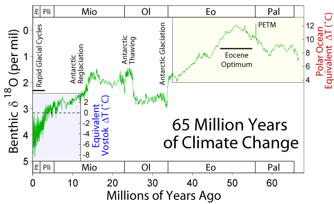
- Time
(the x-axis) on the graph above goes back as you go from left to right
- 18O
is an Isotope of Oxygen that is slightly heavier than 16O,
by far the most common oxygen isotope
- Water
with more 18O will tend to sink
below the surface than water with 16O
- Water
molecules with 18O will require
more energy to vaporize (and will liberate more energy when condensing) than
water molecules with 16O
- The
above facts mean that, as temperatures rise, more O16 water evaporates than
18O water (and more 18O18
water than 16O16 water condenses
as temperatures cool)
- Thus,
the ratio of 18O to 16O
in the oceans changes with changes in ocean temperature (more 18O
when hot, less when cool)
- Calcium
carbonate formation uses water, so the fossil shells from warm oceans
have less 18O than the fossil shells from cooler periods
The
driving force behind the origin of new species is evolution by natural selection.
- We
do not have a good grasp of total global biodiversity
- Is
there value to biodiversity?
- More
biodiverse systems are more stable
- More
biodiverse systems provide greater system services (fresh water, cleaning
air, etc.)
- Greater
potential for valuable species
Measuring
Biodiversity
Species
richness (total number of species) is the most common way to do this
Two
islands
- Island
1 has 5 species and Island 2 has 5 species.
- Which
is the most diverse?
- Island
1 has 2000 of species A, 10 of species B, 10 of species C, 5 of species D
and only 1 of species E.
- Island
1 has 500 of species A, 450 of species B, 400 of species C, 350 of species
D
and only 300 of species E.
- Which
is the most diverse?
- Both
have the same species richness but Island 2 has greater evenness so it
is more diverse
Species
diversity indices (or indexes, if you prefer that plural) have both
richness and evenness components
Biogeography
Biogeography
is the study of how species are spread about spatially. This is an
important component of biodiversity but we will cover this at a later date
Biome Survey
Biomes
are community types often the result of a few important physical factors
Biomes
are types and many specific examples may exist (Deserts occur in almost all
continents)
Terrestrial
Biomes
Climate is
the aggregate of yearly prevailing weather conditions, such as temperature,
humidity, precipitation, air pressure; and is often important in determining
the location of terrestrial biomes and
here
are
some climate
types:
- Tropics -from 23.5°N (Tropic of Cancer) to 23.5°S
(Tropic of Capricorn)
- Day length varies little throughout the year
- Warm, moist weather
- Temperate Zone - ~30 to 50°, both north
and south hemispheres
- Warm summers, cold winters
- Moderate to Low rainfall
- Boreal Zone - ~50 - 66.5°, both north and
south
- cold winter, short summer
- relatively high levels of precipitation
- Polar Zone - above 66.5° Latitude
- low rainfall
and very cold winters
- Mediterranean Climate
- dry, hot summers with cool, moist winters
- Found around the Mediterranean Sea, southern California, Central Chile,
Cape region of South Africa, Southwestern and Southern Australia, and
Northern Argentina
- Subtropics
- region between tropics and temperate zone
- warm and moist to warm and dry
- There are also other "general influences" on
the climate in a region
- Continental and Oceanic effects
- Land heats and cools faster than Oceans
- So, in general, the interior of continents
have wider ranges in climate conditions than do islands or coastal
regions
- Montane effect - Mountains can cause climatic effects
- Adiabatic Cooling - cooling of air as it rises - caused by expansion
as pressure is reduced
- air loses the ability to carry
moisture as it cools, so the relative humidity
increases as air rises and moisture
condenses out so rain falls
on side of mountains where moist surface air is pushed up the mountain
- rain
shadows on the side of mountain where cool air is descending
after being pushed over the mountain (it has lost it moisture)
- mountains can change circulation
patterns on a continental scale
Tropical
Rain Forest
- Abundant rainfall in all
seasons and warm temperatures
- Long growing season, little
seasonal variation, high rate of photosynthesis
(primary productivity high)
- Soils are leached by
rainfall (soluble nutrients removed)
- High diversity of plant and
animal life and lots of biomass/acre
Tropical
Deciduous (Dry) Forest
- Abundant rainfall only in
one season and warm temperatures
- Shorter growing season
than rain forest, little seasonal variation in temperature
- Trees are drought
deciduous, dropping their leaves when the soil dries
out
- High rate of photosynthesis
(primary productivity high) during wet season
- High diversity of plant and
animal life
Tropical
Savannas
- Dry areas with grass as the
ground cover and occasional trees and shrubs
- Warm climate with seasonal rainfall
insufficient for forest development
- Differ from Mediterranean
Climate in that the rainfall comes during the warmer season
- Often occur on flat lands with
nutrient-poor soils
Desert
- High daytime temperatures
(Warm Deserts), except at high
latitudes or elevations (Cold Deserts)
- Water limiting (lack of rainfall
due to latitude or to Rain Shadow effect of mountains)
- Large daily temperature
variation
- No trees, Plants dominated by:
- Annuals -
grow only during wet periods (may not be "annual")
- Succulents that
store water in stems or leaves
- Root
Succulents that store water in underground swollen
roots
- Deciduous Shrubs -
drop leaves when water is limiting
- Plants often have thorns
or spines to protect water resources
- Plant cover may cover less than
10% of soil (none in some areas)
Temperate
Deciduous Forest
- Moderate rainfall
, Temperature goes below
freezing, but not to extremes
- Trees species dominated by a
small number of species (or related species, like the oaks or maples or
hickories)
- Growing season ends with
onset of cold weather and loss of leaves
- Trees shorter than in
rain forest, but canopy is closed
- Plant and animal diversity lower
than in tropical rain forest
- Found in Eastern North America,
Mid-latitude Europe, Japan, Northern China, India
Temperate
Shrublands
- Occur in areas with a Mediterranean
climate
- Xeric (dry)
evergreen shrubs and small Chlorophyll (with
tough leaves having thick cuticles) trees
- Called Chaparral in
North America, Matorral in
South America, Fynbos in
South Africa
- Often subject to a constant
fire regime, burning during the dry season
Grasslands
- Temperate climate,
Rainfall too little for
trees, enough to support 100% ground cover
- grasslands often found
between deserts and forests
- Fire a factor in
maintaining grasslands
- Most of the biomass of
many grassland plants is below ground, where most fires will not
kill the plant
- For millennia, Humans
have kept some landscapes grassland rather than dry forests by setting
fires at regular intervals
- Grazing mammals also a factor
- Large herds (buffalo)
kill young trees
- Lack of moisture slows decomposition
so the soils are very rich in organic material
- Best soils for grain agriculture
- Little natural grassland
left
Boreal
Forest (Taiga)
- Moderate rainfall during
the short, cool summer, Severe winters, drier
than the summer season
- Forest dominated by Conifer
Trees
- Low diversity, but population
numbers can be very high
- short growing season means
the annual productivity of these forests is lower than temperate
or tropical forests
Tundra
- Low rainfall, although Permafrost keeps
soils moist, Extreme cold, short growing
season
- Permafrost is
a layer of frozen soil. Soils freeze and thaw from the top,
where they are warmed by the sun. If the warm season is too
short, the lower portion of the frozen soil doesn't melt - this is
the permafrost.
- Permafrost is
water-proof and so no moisture that falls on soils underlain by permafrost
percolates into the lower groundwater and no groundwater with nutrients
can move up
- Shrub and small trees only,
much open grassland
- Repeated freeze-thaw cycles
over many years push the soil into regular shapes. Click on the name
to see a website with pictures
- Many migratory animals present
during summer months only (many birds nest in the tundra)
Some
other terrestrial biomes
Coastal Pine Forest
- Sandy, low nutrient soils, fire
common
- Southern Alabama, Mississippi,
coastal Carolinas and Georgia
Temperate Rainforest
- Very wet temperate climate,
trees dominated by conifers
Alpine
(sometimes montane is
used instead of alpine)
- these communities occur as you
ascend mountains and are similar to biomes you find as you go north
- Rainfall increases on windward
side, decreases on leeward side (Rain Shadow)
Aquatic
Biomes
Fun water facts
- Water is densest at 4° C, so
the bottom of the ocean is always 4 °C
- Cold water holds more O2 than
warm water, so warm water can asphyxiate fish
Freshwater Ecosystems
Lentic habitats
are wetland, lake and pond communities
Freshwater-Marine
Interface - Estuaries,
Barrier Islands, Mangrove Forests and Salt Marshes
- Estuaries are
where fresh and salt water mix, stressful for organisms - Mudflats and
marshes common - High primary productivity but
low species diversity
- animals must deal with
- maintaining their position
in the marsh as tides and river flow mean that the water is constantly
moving but not always in the same direction
- adjusting to varying levels
of salinity as the estuary has a
gradient of salinity from freshwater in the river to ocean salinity
near the mouth of the estuary and the gradient can move with
the tides
- Barrier
Islands form
where sand is carried toward shore by waves until it piles into low
islands of sand just off of the coast
- Lagoons -
the waters between the coast and the back side of the barrier islands
- Mangrove
Forests (Mangals)
- found on tropical, low energy (sheltered, waveless) coasts
- productive systems that are important fish nurseries
- Salt
Marshes -mudflats
in temperate regions dominated by a type of grass called
cordgrass in the genus Spartina
- high productivity areas
because of the input of nutrients with each tide
- much of the
productivity is available to the predators (fish and crabs
or birds and mammals)
that come and go with the tides so salt marsh productivity
supports coastal fisheries
Marine
Communities (Oceans)
- Intertidal
zone
- Pelagic Zone -
the waters of the ocean
- Neritic
Zone - shallow
ocean over the Continental
Shelf
- Continental
shelf is
the edge of the rock
formations that make
the continents -
lighter rock
that "floats" on
the more dense rock
of the ocean floor
- Oceanic Zone - deep,
open ocean - water column broken into zones (fish
differ in each zone)
- Benthic Zone -
the bottom of the ocean
- mostly non-productive (food has to fall from surface - mostly mud
- ocean averages almost
4 km deep (closer to 5 km if the neritic zones are not included in
the calculation), so the benthos is:
- uniformly cold (4°C
water is densest and sinks to the bottom)
- under tremendous
pressure (~1 atmosphere for every 10 m of depth, so 4 km deep
means about 390 atm, or over 5,700 pounds per square inch)
from the weight of the water above
- Volcanic vents
- Sea floor spreading
causes volcanism
- as hot mantle
material comes to the surface it cools and forms the
Midocean Ridges
- where the ridges
or other volcanic activity on the sea floor is, vents can form
- vents are home to
one of the most unusual ecosystems on Earth, only discovered
in 1977
s22
Last updated January 30, 2012